
 Abstract
- This article describes the main approaches adopted in a study focused on planning industrial estates on a sub-regional scale. The study was supported by an agent-based model, using firms as agents to assess the attractiveness of industrial estates. The simulation was made by the NetLogo toolkit and the environment represents a geographical space. Three scenarios and four hypotheses were used in the simulation to test the impact of different policies on the attractiveness of industrial estates. Policies were distinguished by the level of municipal coordination at which they were implemented and by the type of intervention. In the model, the attractiveness of industrial estates was based on the level of facilities, amenities, accessibility and on the price of land in each industrial estate. Firms are able to move and relocate whenever they find an attractive estate. The relocating firms were selected by their size, location and distance to an industrial estate. Results show that a coordinated policy among municipalities is the most efficient policy to promote advanced-qualified estates. In these scenarios, it was observed that more industrial estates became attractive, more firms were relocated and more vacant lots were occupied. Furthermore, the results also indicate that the promotion of widespread industrial estates with poor-quality infrastructures and amenities is an inefficient policy to attract firms.
- Keywords:
- Industrial Estates, Agent-Based Models, Firms
Introduction
- 1.1
- The creation of industrial estates is based on economic, territorial and environmental objectives. Appropriate planning is an essential condition for the success of an industrial estate. In turn, inadequate planning can keep away firms and can thus require additional costs and efforts to increase the attractiveness of these spaces. These issues are more critical if public policies contribute to increasing the supply of industrial land without coherent and sustainable criteria. This is the case of Portugal, where municipalities have supplied a considerable number of industrial sites over the last decades to facilitate and stimulate economic development in a municipal struggle for firms and employment. As a result, a number of undesired market outcomes have occurred which makes this analysis more interesting.
- 1.2
- This study uses an agent-based approach to assess the impacts that different policies can have concerning the attractiveness of industrial estates. The model was applied to a territory located in Portugal, comprising an urban network of four municipalities. Policies were distinguished by the type of intervention and by the level of coordination at which these were implemented by the municipalities. The policies were conceived to simulate the impact of three scenarios and to validate four hypotheses related with their implications. The simulated scenarios were the following: 1) maintenance of uncoordinated policies and poor-quality infrastructures by the municipalities; 2) adoption of a municipal coordinated policy of qualification of all the industrial estates; 3) impact of the strategies predicted by the municipalities in a scenario of: low qualification (3a); and advanced qualification (3b). The strategies predicted in scenario 3 were based on the individual initiatives of each municipality and comprise the expansion of the existing industrial estates and the creation of new sites. These three scenarios were conceived regarding four hypotheses as described in the Methodology section.
- 1.3
- Besides the introduction, this article consists of three main sections. The first one comprises a theoretical framework of the subjects under analysis. The methodological approach used in the study and the main steps followed to construct the model are described in the second section. The results and the main findings obtained from the model are discussed in the third section, which is followed by the conclusions and some final remarks.
Firms
and industrial estates planning in agent-based models
- 2.1
- An industrial estate can be defined as a site developed by a promoting authority to accommodate a number of different companies. Industrial estates are subdivided into lots according to a comprehensive plan providing common facilities (water, electricity, sewage disposal, gas, optical fibres, etc.) and amenities (security services, cleaning services, service stations, restaurants, recreational and social equipment, etc.). Creating industrial estates is associated to various economic, territorial and environmental benefits. Through industrial estates, firms benefit from economies of scale in terms of land development, construction and common facilities. Industrial estates offer managed/serviced workspace (or lots on which to build these) with collective access to utilities, facilities and amenities (reducing the cost and making their provision and maintenance more efficient). Furthermore, close proximity can encourage cooperation among firms within an estate. As industrial estates are commonly planned in the peri-urban spaces, they can decrease congestion and pollution in urban areas, contribute to reducing traffic, increasing the efficiency of urban land use and reducing various costs (land development, provision of utilities, etc.).
- 2.2
- The success of an industrial estate is highly dependent on appropriate planning (location, facilities and amenities provided at the site, etc.) and on adequate management (maintaining the infrastructure and promoting the space). Despite the concept being widespread, the subject of industrial estates has received relatively little attention in the literature. Some of the topics studied in-depth include: the emergence and evolution of the concept of industrial estates (Scott 2001; Altes & Tambach 2008); the goals intended by public policies to create industrial estates in many countries (Udayakumar 2010; Krabben & Buitelaar 2011) and the different typologies of industrial estates and their territorial framework (Mazzarol et al. 2009). In this context, particular emphasis has been given to the typology of eco-industrial parks (Bizukojc et al. 2009; Boix et al. 2015).
- 2.3
- Considering the planning domain of industrial estates, there are also some studies, which include different approaches. For instance, the study carried out by Mazzarol et al. (2009) describes a guide for planning and managing industrial estates. Pablo et al. (2013) applied multivariate analyses to understand whether the industrial estates located in Galicia (Spain) were planned so as to incorporate horizontal differentiation strategies to meet the requirements of firms. On the other hand, Fonseca and Ramos (2010) used a multi-criteria analysis in a planning study carried out in the Portuguese region of the Ave valley. The authors proposed a regional network of the industrial estates based on their ranking, addressing specific actions for the different levels of each estate (local, municipal and regional). Ruiz et al. (2012) also used a multi-criteria analysis for planning sustainable industrial areas in Cantabria, Northern Spain. The model developed include 75 variables related with sustainable development principles. The multi-criteria evaluation was complemented by using the integration of different tools, namely GIS software and a fuzzy-rule based expert system. The multi-criteria model allows the creation of digital maps where the different zones can be distinguished according to their suitability for the location of potential industrial areas. Also common are the spatial analysis that use GIS to select the most suitable location for the firms. For instance, Puente et al. (2008) developed a GIS model with three geographic levels (regional, municipal and local) to select the most appropriate site to set up an industrial area. Manzato et al. (2010) used a GIS model to make a list of possible locations in the Netherlands territory, depending on the specific needs of each industrial sector. In a similar approach, Rikalovic et al. (2014) also used GIS techniques to find alternative options to select industrial sites.
- 2.4
- In addition to these spatial analyses, there is a growing number of planning approaches that use geo-simulation tools, such as agent-based models (ABMs) (Matthews et al. 2007). Agent-based modelling is a form of computational simulation that entails two main entities: agents and the environment (Gilbert 2008). Agents are computational entities with attributes. They can develop mental states, interact with other agents and with the environment, move around the environment, collaborate or compete with other agents in a task, etc. The environment is the virtual world where the agents are inserted; it can be completely abstract or represent a real world (a city for instance) and influence the agents' activity (providing food or water for example). Thus, agents are appropriate to represent entities or objects (people, organisations, vehicles) and their interactions, while the environment is more suitable to represent the territory (plots of land, lots, etc.). The advantages of using ABMs in the planning domain include: (i) the capacity to represent the heterogeneity of the territorial entities and their interactions; (ii) a bottom-up approach, where the macro tendencies come from the interactions undertaken at an individual level; (iii) the capacity of reproducing the spatial behaviour of entities/objects; (iv) and the capacity of representing the evolution of a phenomena over time.
- 2.5
- In the planning domain, ABMs have been used to study a wide range of urban and territorial phenomena, such as land use changes, urban growth, accessibility, gentrification, among many others. Location has been one of the most investigated topics. This is a problem that involves many entities (inhabitants, businesses, public administration, etc.) aiming to respond to the basic question: where should I locate to? In fact, the location decision arises from a complex process, where individual aspects are articulated with economic, social and political factors (Crooks 2010). Regarding the firms, ABMs applications can be divided into two main applications (Khan 2002): (i) organisational and relational issues between the firms; (ii) and the location issues. In fact, the first multi-agent systems were developed in the 1980s in the industrial domain aiming at the improvement of the internal processes of production. YAMS and ARCHON are two examples of these models (Jennings & Wooldridge 1998). Over recent years, many other applications have been developed with the purpose of increasing industrial productivity. Research carried out by Forget et al. (2008), Gao et al. (2009) and Chan et al. (2012) are examples of these applications. Furthermore, relations between the companies have also inspired many ABMs, mainly where a high number of firms is located, such as in industrial districts and clusters. These models were developed with different purposes, namely: to evaluate the advantages of clustering the firms in specific areas (Squazzoni & Boero 2002; Fioretti 2006); to analyse the competition, collaboration and cooperation among the firms (Albino et al. 2003); to study how innovation spreads between them and other institutions (Ahrweiler et al. 2004; Albino et al. 2006); and to assess how these industrial areas grow and develop over time (Giardini et al. 2008; Cao et al. 2009).
- 2.6
- The ABMs focused on location issues mainly consist of two types of applications: (i) generic models of land use change; (ii) and specific models that use firms as the only entity of agents simulated. In the first case, firms are usually one of the entities simulated due to their implication in urban development, land demand, location of residential areas and traffic generation (Timmermans 2003). These generic models consist of a changeable number of modules, one for each simulated entity. The firm module controls how these agents interact with each other and with the remaining agents (inhabitants, real estates, public entities, etc.). There are several examples of these models, such as Urbansim (Waddell 2002), Ilute (Miller et al. 2004) and ILUMASS (Moeckel et al. 2003). The second category consists of the firmographic models and the location models themselves. The focus of the firmographic models is to analyse firms' life cycles in a specific territory. These models are also suitable to study the implications of firms in terms of jobs, urban development and mobility, as well as to anticipate their location and relocation decisions (Maoh & Kanaroglou 2005; Kumar & Kockelman 2008). The development of these ABMs is often constrained by the lack of disaggregated and continuous data on an individual scale of the firms. Thus, the number of ABMs developed in this topic is more restricted. The models of Wissen (2000), De Bok (2007), Maoh and Kanaroglou (2009) and Manzato et al. (2011) are some examples of this type of application. The same problem (lack of individual databases related with firms) justifies the smaller number of models developed with location purposes. Using these applications, the most suitable location for a specific firm can be identified, depending on several criteria. The ABLOoM model (Otter et al. 2001) and the work carried out by Manzato (2012) are two examples of simulations developed in this domain.
- 2.7
- The model proposed in this paper adds to the topic of locational ABMs, by using firms and industrial estates as the only categories of agents simulated. The aim is to use firms to test the attractiveness of the industrial estates located in four municipalities considering three scenarios that correspond to different planning policies. In this context, we have not found any ABM developed for industrial estate planning with a similar purpose. Moreover, this study provided an important opportunity to better understand collaborative and integrated planning that involves neighbouring municipalities working together, which is a topic not often explored in the literature (Levy et al. 2011).
Methodology
- 3.1
- In the context of industrial estate planning policies, this article summarises the main steps of a study carried out in the Quadrilátero, designation given to an urban network consisting of four municipalities (Barcelos, Braga, Guimarães and Vila Nova de Famalicão) located in the Northern region of Portugal. These four municipalities are engaged in a project to improve the competitiveness and internationalisation of the territory. Adopting coordinated planning policies that also include industrial estates is seen as a key element to improve the economic performance of the territory. Thus, the model presented in this article was directly inspired in these principles.
- 3.2
- The methodological procedures adopted in the study will be
described below according to the following order: (i) general purpose
of the model; (ii) description of the data collection process; (iii)
definition of the rules and how the model works; (iv) and description
of the scenarios and the hypotheses to be tested using the model.
(i) General purpose of the model
- 3.3
- The model was developed with the aim of supporting and improving the planning of industrial estates on a scale of four municipalities. Adopting accurate planning policies is a requirement for these spaces to become more attractive to firms. They are also important to encourage industrial development and entrepreneurship, as well as strengthen the economic and territorial competitiveness. These generic goals seem to be even more important as economic growth is seen as the only way to overcome the crisis. In Portugal, industrial estates have been actively promoted by the municipalities over the last two decades. The municipal policies have led to the creation of many industrial estates which are widespread around the territories, and are usually poorly-qualified in terms of infrastructure and without functional and territorial organisation and management. For these reasons, many authors argue that Portuguese estates do not match any of the economic, territorial and environmental criteria related to their promotion (Silva et al. 2008). In order to solve this problem, public policies have appeared to support the qualification of the industrial estates and to encourage their physical and functional organisation in sub-regional networks. The goal is to explore the synergies that can arise from these articulations (more critical mass and scale effects) and to make the actions adopted more rational and sustainable.
- 3.4
- In this context, the main aim of the model is to estimate the impact that different planning policies can have on the attractiveness of industrial estates. Policies were distinguished by the level of municipal coordination at which these are implemented and by the type of intervention simulated. Coordination can be understood as collaborative and integrated planning that involves the four neighbouring municipalities considered. In practical terms, coordinating policies means that the whole planning process and the creation of industrial parks is done in conjunction with the four municipals. The intention was to demonstrate which institutional framework can bring more benefits in terms of capacity to attract firms. On the other hand, in the model, each simulated policy corresponds to a different type of intervention in the industrial estates. The model was performed to estimate the impacts of providing a basic or an advanced coverage by facilities and amenities. An industrial estate with advanced coverage is classified as a qualified site when compared with estates that only offer basic infrastructure (poorly qualified sites). Despite the dominant pattern of small firms from specific sectors (textile and clothing), a wide range of companies installed at the industrial estates can be observed, which makes it difficult to identify the infrastructures and amenities needed for each one of them. Thus, the advanced components added to the simulation in some scenarios were not based on location factors that would be important for a specific activity, but rather on the needs highlighted by the entrepreneurs during the survey. They can be seen as needs that cross all the industrial sectors. The advanced facilities considered were access to broadband, natural gas and sewage treatment. In terms of amenities, the availability of some services, such as bars/restaurants, public transport, cleanliness and security were also included as advanced, considering the needs of the firms installed and the absence of these services in most of the sites.
- 3.5
- As mentioned above, the simulation of different scenarios intended to assess which type of intervention would be more effective to boost the attractiveness of the industrial sites located in the four municipalities. In this context, attractiveness can be defined as the capacity of an estate to attract firms. Attractiveness was conceived as a characteristic that reflects an opportunity of location. It was not regarded as a pre-given natural property of a particular estate, but instead as a changeable component that mostly depends on the coverage in terms of facilities, amenities, accessibility and price of land. Despite influencing the attractiveness, management issues at the industrial estates were not directly considered in the model due to the lack of any entity at the municipal or sub-regional levels which has this function. Indirectly, the policies simulated by different levels of municipal coordination can be seen as a first approach to have a broader process of management on a sub-regional scale.
- 3.6
- The agent-based approach was adopted mainly for two
reasons. Firstly, the use of this approach brings many advantages
compared to other techniques/tools of spatial analysis. Having an ABM,
firms can be represented on their individual scale, with their
heterogeneity and location preferences. The different attractive
conditions of the estates can be represented on an individual scale as
well. Thus, a natural description of the territory can be made using an
ABM, enabling companies and industrial estates to interact directly and
individually without any type of intervention in the selections made by
the agents. Secondly, with this type of simulation, the states and
rules that control the behaviour and interactions between the agents
can be easily changed. This flexibility is important to create
different scenarios by changing the attractive parameters of the
estates and/or the location preferences of the firms (considering their
dimension, their activity sector, etc.). Hence, when compared with
other spatial analysis tools, the ABM approach seems to be more capable
of accurately replicating the targeted problem.
(ii) Data collection
- 3.7
- The initial intention was to develop a spatially explicit model to reproduce the conditions found in the territory in terms of firms and industrial estates. In the case of the firms, only the industries were considered, because the estates are mostly promoted to attract this specific type of firms.
- 3.8
- One of the first problems to construct the model was the lack of individual and disaggregated data related to estates and firms. In the case of the estates, data was gathered by using a survey addressed to the municipal services with the aim of collecting information about the location and the general characteristics of each industrial estate (areas, number of lots, number of installed companies, price per m2, and the coverage of 16 facilities and 14 amenities). Furthermore, the survey included some questions to discover the strategies predicted by the municipalities, namely to understand whether the existing supply would be enlarged in the future by creating new estates or by expanding the existing ones. This information was then used to estimate the attractiveness of the new estates and their impact on the existing ones (scenario 3). Including this information can also be helpful to find out if the policies are rational from the territorial point of view. As the data collected from the surveys had several gaps, all the 79 industrial estates identified were visited in order to obtain the missing data and to check all the information provided. The data collected showed the existence of common patterns in the four municipalities considered. The most remarkable feature was the territorial diffusion of many small estates, with basic infrastructure and a notable lack of amenities. The global conditions found in the territory are compatible with the main conclusions of other studies developed in the region (Silva et al. 2008) and highlight the need to adopt planning policies to overcome these weaknesses.
- 3.9
- During the fieldwork, business owners located in the industrial estates were also interviewed. The final number of surveys carried out was 78 (9% of all the firms located in the industrial estates). The sample was previously segmented to reflect the number of firms located in each estate and their size and sector of activity. The aim of this survey was to learn about the past and future location behaviour of the entrepreneurs and their satisfaction level regarding the provided conditions. The data obtained from this survey was helpful to calibrate the model. In short, the survey showed that the majority of the firms (88%) were not previously located in an industrial estate, but had a disperse location. Furthermore, the survey showed that the relocated firms are predominantly micro and small sized (78%) and are from the most representative sectors found in the region (textile, clothing and metal industries). Moreover, the survey indicated that 90% of the entrepreneurs were reasonably satisfied with the conditions provided. As a consequence, they were not interested in moving to another estate.
- 3.10
- In the case of the firms, the source used was the
Integrated Business Accounts System (SP
2011) due to the lack of a geo-referenced database with the
individual location of the firms. This database is compiled by the
Portuguese Statistics Institute, containing disaggregated data about
firms, including location, sectors of activity, number of employees,
turnover, etc. Based on the location provided, the 4,722 firms of the
database were mapped through points using the ArcGis software. Then,
all the points were linked to the respective attributes stored in
tables. According to the database (SP, 2011) 82% of firms were located
outside of an industrial estate, 93% were small and medium sized firms,
83% had a turnover of less than 1 M€/year and 57% belong to the
textile/clothing sectors. Thus, the industry is based on small
companies, spread around the territory, from so-called traditional
sectors (textiles and clothing), which are very exposed to
international competition.
(iii) Definition of rules and how the model works
- 3.11
- Once the data was collected, the next step was to define
the rules that control how the model would run. The definition of the
industrial estates' attractiveness was the starting point of this task.
Following the recommendations of Bodenmann and Axhausen (2010), the attractiveness
was based on the level of facilities, amenities, accessibility and on
the price of land found in each industrial estate. Based on the
presence (1) or on the lack (0) of the different facilities and
amenities, the respective coverage (in percentage) was estimated for
each site, according to the formulas shown in Table 1.
Table 1: Criteria used in the evaluation of industrial estates' attractiveness Facilities Amenities Accessibilities \(R_{\rm facili}= \frac{\sum^n_{i=1} (\mathrm{facili}_i)}{n} \times 100\) \(R_{\rm ameni}= \frac{\sum^r_{i=1} (\mathrm{ameni}_i)}{r} \times 100\) \(R_{\rm access}= \frac{\sum_{i=1}^t (\mathrm{access}_i)}{t} \times 100\) n: number of facilities analysed (16) r: number of amenities analysed (14) t: number of accessibilities analysed (5) - 3.12
- Accessibility was estimated considering the distances to a
set of transportation infrastructures that often influence the location
of firms (Ramos & Mendes 2001;
Fernández & Ruiz 2009).
The transportation infrastructures considered were: national roads,
motorway intersections, railroad terminals, seaports and airports.
Although some of them are not decisive, considering the nature of the
firms installed (such as the seaport and the airport), the proximity to
these infrastructures is very relevant to improve the
internationalisation and competitiveness of the industrial estates
located in the Quadrilátero. The distances were calculated through the
road network that connects each estate to the respective
infrastructure. Following the method proposed by Ramos and Mendes
(2001) in a study undertaken in the Northern region of Portugal, the
accessibility levels (Table 2)
can be classified as: excellent (\(\leq D (D\max /
2)\)), moderate (\(D\max < D \leq (D\max /
2)\) or bad (\(D < D\max\)). Based on this
classification, different weights were assigned to each estate (1 =
excellent; 0.5 = acceptable; 0 = bad) through which their final
accessibility values (in percentage) were estimated, according to the
formula shown in Table 1.
Table 2: Criteria used in the evaluation of accessibility Max Distance
(km)Description of Accessibilities Excellent
(1)Moderate
(0.5)Bad
(0)3.49 National roads proximity \(D\leq1.745\) \(1.745 < D \leq 3.490\) \(D > 3.490\) 27.36 Motorway intersections proximity \(D \leq 13.680\) \(13.680 < D \leq 27.360\) \(D > 27.360\) 51.91 Seaport proximity (Leixões) \(D \leq 25.955\) \(25.955 < D \leq 51.910\) \(D > 51.910\) 69.90 Airport proximity (Oporto) \(D \leq 34.950\) \(34.950 < D \leq 69.900\) \(D > 69.900\) 20.08 Railroad terminal proximity \(D \leq 10.040\) \(10.040 < D \leq 20.080\) \(D > 20.080\) Source: Ramos and Mendes, 2001. - 3.13
- Regarding costs, various variables were considered, but in the end only the price of land was included, concerning the average price identified in each estate. In fact, the fieldwork showed that the labour and the utilities costs were identical due to the sub-regional scale of the study. Furthermore, the price of land was the most difficult variable to identify due to its strong variation from lot to lot and to the presence of several owners/promoters in each estate.
- 3.14
- Regarding the firms, it was assumed that relocation is not a random process. Following the conclusions of the survey, the size, the conditions provided by the site and the distance to the closest industrial estate were considered the most relevant issues with implications in the relocation process. Since the supply is targeted for small firms, it was assumed that only the small and micro firms could relocate in an estate. In fact, the existing estates do not have physical conditions to receive large firms, mainly because the lots are too small. Moreover, the tendency of a large firm moving to a relatively near location is lower due to the high costs involved. Regarding location, it was also stipulated that relocating firms would be those with a disperse location, having a bad (0) coverage in terms of accessibility, facilities and amenities. Since the facilities and amenities coverage in the area of the spread out firms was unknown, it was assumed that firms located in rural areas and predominantly rural spaces would have a worse coverage (0) than those located in urban areas (1). The distinction between urban and rural spaces was made by the Classification of Urban Areas published by the Portuguese Statistics Institute at the statistical subsection unity (the most disaggregated available). Finally, the maximum range of relocation of a firm was set at 20 km. This criterion related with distance was introduced because the survey showed that most relocations occur within the same municipality.
- 3.15
- After concluding the theoretical procedures of the model, the next step was to select a suitable toolkit to run the simulation. After evaluating several options, the NetLogo toolkit was chosen for three main reasons. Firstly, NetLogo has a GIS extension that supports vector data in the form of ArcGis shapefiles, where all the geographic information was initially processed. Secondly, NetLogo does not require advanced programming experience and has a large community of users. Thirdly, NetLogo is a freeware toolkit suitable for simulating the problem.
- 3.16
- In the NetLogo, industrial estates are represented by patches, which correspond to many grids in which the NetLogo environment is divided. Each patch is a square piece of ground with coordinates that cannot move but over which other agents (turtles) can move. This type of agent is, therefore, particularly appropriate to represent immovable territorial entities such as the estates. Each industrial estate was represented by a changeable number of patches containing information about the conditions offered by the site, in order to define the attractiveness. Thus, each patch contains specific information about the coverage (in percentage, according to Table 1) of facilities, amenities and accessibility, as well as the average price of land. Each of these attractiveness components were operationalised with values that reflect the conditions identified in the territory. The different planning policies and scenarios were simulated by changing these values, as described below.
- 3.17
- In turn, firms were represented by turtles. This type of agents can move around the NetLogo world, and are more suitable to represent firms and their relocation process. Each one of the 4,722 firms was represented by a turtle. Each turtle had attributes related with dimension and location, considering the distance to transportation infrastructures and the territorial context that determines the coverage of facilities and amenities. All the attributes (from the firms and the industrial estates) were imported from ArcGIS by the GIS Extension of NetLogo.
- 3.18
- Once the attributes of patches and turtles were established, the next step was to define the rules. Turtles have the ability to move around the environment, interacting with patches to find a better location. However, not all turtles can do that. As a consequence, the first rule controls those that can relocate, based on the findings from the survey. As the goal is to assess the attractiveness of the industrial estates, only the turtles with diffuse location (settled outside an industrial estate), which correspond to micro or small firms with bad (0) coverage of infrastructures, amenities and accessibility, can relocate. Then, the model has a second rule to control the spatial behaviour of turtles. This rule was also inspired by the conclusions obtained from the survey. The maximum distance that one turtle can move was limited to 20 km. Furthermore, turtles do not have pre-defined preferences for any specific industrial estate or for any municipality and can move to any of them according to the established criteria. A third basic rule establishes the patches' attractiveness, namely the lowest percentage from which the sites are no longer attractive in each scenario. These values were estimated in accordance with the criteria described above (Table 1), considering the global average obtained by the 79 sites in each component that defines attractiveness (Table 3). Furthermore, the model incorporates a rule to define the vacant lots and to control how these lots are occupied. The number of vacant lots corresponds to those identified in the industrial estates, and are a specific attribute of the patches. Only patches having vacant plots can attract turtles. In the relocation process, when a turtle settled on a patch, a vacant lot is deducted, ending the process when all the vacant lots are occupied by turtles (or when there are no more relocating turtles).
- 3.19
- The definition of these rules leads to some assumptions. In
the model, firms (turtles) interact with estates (patches) looking for
a better location in an industrial estate. The relocation only occurs
if the new site represents an improvement of the conditions experienced
by the firm and if the estate has vacant lots. Both the turtles and the
patches are competitive: the first ones compete for a suitable location
in an estate, while the estates compete for attracting new firms. In
the model, relocation correlates with attractiveness. Turtles only
relocate if the new site represents an improvement of the global
conditions offered. The model assumes that only the sites with a better
coverage in terms of facilities, amenities and accessibility represent
an opportunity to boost the firms' activity. Doing the opposite would
not make sense as it would represent a loss of competitiveness of the
industrial estates. Furthermore, attractiveness correlates with
vacancy, e.g., having vacant lots or available space to install new
firms. Without available space, the estate loses the capacity to
attract new firms, even if the coverage by facilities and amenities is
advanced. Thus, the existence of vacant lots is a pre-defined condition
to receive firms, which decreases as vacant lots are occupied by new
firms. The model also assumes that any firm, considering the criteria
established, can relocate in an estate. Obviously this assumption does
not take into consideration the internal process that determines the
relocation of a firm, and this is a dimension more related with the
demand than with the supply of industrial land (the focus of the
study).
(iv) Description of the scenarios and hypotheses
- 3.20
- As described before, the model was conceived to assess the impacts of different planning policies in the industrial estates' attractiveness of an urban network. The four municipalities of the network are engaged in adopting common planning policies and in improving their industrial estates. Following this framework, policies were simulated using three scenarios which differ in the type of interventions and in the level of municipal coordination where they are implemented. Interventions are related to basic (poor-qualified) or advanced infrastructures, while coordination means that a policy is equally implemented by the four municipalities. The goal of the urban network is to create conditions to launch a coordinated policy to improve the capacity of attracting firms. Thus, the scenarios were defined to understand the impact and the potential benefits that could result from the application of these policies at the level of the existing parks, as well as that foreseen for the future. According to this, the scenarios simulated are as follows: 1) maintaining an uncoordinated and poor-quality infrastructure policy by the municipalities; 2) adopting a coordinated policy of qualification of all the industrial estates; 3) impact of the strategies predicted by the municipalities in a scenario of low qualification (3a) and of advanced qualification (3b).
- 3.21
- The first scenario corresponds to the starting point, to the situation identified in the territory, where each municipality individually plans its own estates and where the estates have a low coverage of facilities and amenities. The results obtained from this scenario will work as a referential and can be used to evaluate the impacts of the planning policies simulated in the other scenarios. In turn, scenario 2 simulates the effect that a coordinated policy of qualified infrastructure can have in the attractiveness of the industrial estates located in the four municipalities. Qualification here should be regarded as a broader infrastructural improvement carried out by the municipalities. The goal is to estimate the impact of such an action in the industrial estates' attractiveness, to analyse which estates become attractive and to check if this policy will contribute to bridge the gap of significantly different conditions detected at the municipal and sub-regional levels. The third scenario takes into consideration the planning strategies addressed by the municipalities for the industrial estates, including creating new spaces and expanding the existing ones. The aim is to understand how to carry out this future supply and how to estimate the impacts on existing estates. To achieve this purpose, two simulations were carried out. In the first one (scenario 3a), the predicted strategies are simulated in a context of poor-qualified infrastructure and the absence of municipal coordination. In the second one (scenario 3b), the same strategies were simulated as being implemented in a context of advanced-qualified infrastructure by the four municipalities. The two scenarios were implemented to show which strategies would be more efficient in attracting firms.
- 3.22
- The rules described in the previous subsection were equally used in the simulation of the three scenarios. The impact of each planning policy was obtained by changing the level of attractiveness of industrial estates and by shifting the location requirements of the firms. For instance, the improvement simulated in scenario 2 and 3b came from not only including some basic facilities and amenities that are missing in some estates, but also from incorporating more advanced infrastructures and services. As a result of this improvement, the average coverage and consequently the attractiveness of all the sites will be higher in these two scenarios. After having improved the general conditions offered by the estates, it was assumed that the location requirements of the firms would be higher too.
- 3.23
- Thus, for each scenario, the relocation requirements of
firms should be greater than the minimum value that results from the
global average achieved by the 79 sites in each component of
attractiveness (facilities, amenities, accessibility, and price of
land). The lowest values considered in each scenario are presented in
Table 3, where the
infrastructural improvements are easily detected in scenarios 2 and 3b.
Table 3: Minimum requirements considered for the relocation of firms Scenarios Facilities Amenities Accessibilities Price of land (€/m2) 1 \(\leq 54.6\)% \(\leq 19.9\)% \(\leq 56.8\)% 2 \(\leq 73.2\)% \(\leq 42.4\)% \(\leq 58.9\)% \( 733\) 3a \(\leq 50.1\)% \(\leq 18.6\)% \(\leq 58.2\)% 3b \(\leq 61.4\)% \(\leq 30.1\)% \(\leq 58.2\)% - 3.24
- The model was also used to validate four hypotheses related
to the impact of the policies for industrial estates and to estimate
the effectiveness of these policies to solve some problems. The
envisaged hypotheses were the following:
- Coordinating the planning policies among the four municipalities increases the attractiveness of all the industrial estates. The aim is to confirm if the adoption of coordinated planning policies improves the number of firms installed in all the industrial estates of the Quadrilátero.
- Coordinating the planning policies leads to a common pattern of estate occupancy in all the municipalities. In this case, the objective was to check if the adoption of coordinated planning policies can alleviate the different levels of attractiveness of each municipality.
- Policies to provide advanced-qualified infrastructure improve the occupancy rate of all the estates. This hypothesis tries to confirm if a higher qualification level improves the industrial estates' attractiveness by a higher occupation of the vacant lots.
- Creating spread out industrial estates with poor-quality infrastructures and amenities is an inefficient policy to attract firms. The purpose intended with the latter hypothesis is to confirm if the policies followed by the municipalities are efficient in attracting firms.
Results
and discussion
- 4.1
- This section summarises the main results of the scenarios simulated to assess their impact on the attractiveness of industrial estates. Additionally, the results will be used to validate (or not) the four hypotheses described above.
- 4.2
- Despite the low level of location requirements given to firms in scenario 1 (which represents the current situation and the beginning of the simulation), the results show that most of the industrial estates remained unattractive to firms (Figure 1 and Table 4). In fact, the lowest number of relocated firms was attained in this scenario (235) and 404 of the available lots remained vacant (37% of the available supply). From the 79 industrial estates identified in the territory, only 24 were able to attract firms. The conditions diagnosed in the territory largely explain the performance observed from this scenario. Attractiveness is largely conditioned by the very low coverage of amenities. In fact, the global average of the amenities coverage is 19.9%, but there are many estates with a coverage value of only 10%. In five of them, the coverage level falls to 0%. The low coverage in terms of facilities (16 estates have coverage values below 50%) and accessibility (15 estates have coverage values under 50%) also contribute to the low performance shown by the industrial estates in this scenario. These problems arise from the municipal policies adopted, which contribute to spreading a significant number of small estates with low levels of qualification by the municipal territories. This is particularly evident in Guimarães, Barcelos, and Vila Nova de Famalicão. In fact, the peripheral areas of these municipalities, where many estates are located, are not served by many facilities/amenities, they are distant from many transportation infrastructures, and they have the worst levels of accessibility.
- 4.3
- The impact of a coordinated qualification was tested in
scenario 2 (existing estates) and 3b (including the predicted estates).
The results show that this policy has a positive impact on the
capability of industrial estates to attract firms. Regarding the
existing estates, the comparison with the results obtained from
scenario 1 (Figure 1 and Table 4) indicates that there are more
attractive industrial estates (+26), the number of relocated firms more
than doubled and the number of vacant lots was substantially reduced
(-291).
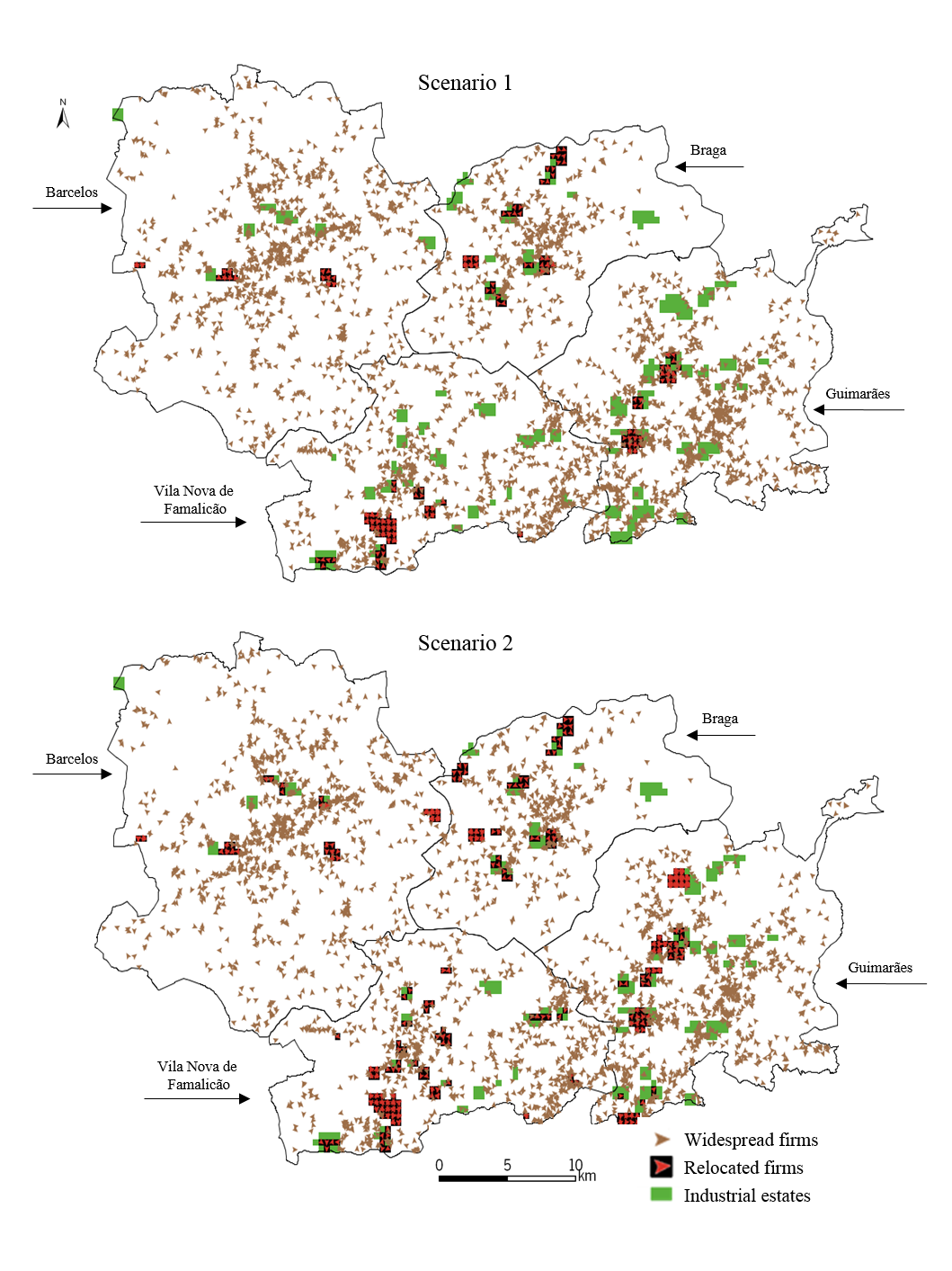
Figure 1. Results of the simulation in scenarios 1 and 2 - 4.4
- In the case of the scenarios that include the predicted strategies, the simulation showed that the most efficient policy was the provision of qualified estates (scenario 3b). In scenario 3b, the number of relocated businesses is considerably higher (+223) and the number of vacant lots decreases proportionally (from 917 to 694). These results clearly demonstrate that qualification is an important action to improve the attractiveness of industrial estates. However, these results only partially validate hypothesis 3. The qualification policy improves the occupancy rate of the estates, but many remain unoccupied. In fact, in scenarios 2 and 3b, many estates remain unattractive even if qualified. Scenarios 2 and 3b show that the industrial estates that remain unattractive have predominantly a peripheral location in each municipality. The investments to strengthen the facilities and the amenities coverage in these spaces improve their attractiveness, but they remain unattractive on a sub-regional scale. Thus, even after improving the general conditions of the estates, most of them will remain unattractive, and the estates from the peripheral location will be more affected. The financial costs of implementing such a policy were not analysed in this study. However, results suggest that investments in the infrastructures and amenities of the peripheral industrial estates would not have a great impact on the level of their capacity to attract companies.
- 4.5
- Results also suggest that implementing coordinated planning policies (i.e. adopting the same action by the four municipalities) can be more efficient in the location performance of the industrial estates than the individual initiatives taken by each municipality. In the cases of both existing and predicted estates, coordination brings about more attractive estates (except for scenario 3b), a smaller number of vacant lots and a greater number of relocated firms (291 more in scenario 2 and 223 more in the case of scenario 3b). These benefits are extensive to all municipalities, especially those where accessibility is more favourable (Vila Nova de Famalicão and Braga). Thus, the results show that a coordinated action has a global positive impact on the attractiveness of industrial estates. Nonetheless, these results only partially validate hypothesis 1. It means that adopting coordinated policies increases the location performance of many estates, but a significant number of them remain unattractive (Figure 2 and Table 4), mainly those located in peripheral areas of each municipality. On the other hand, results do not validate hypothesis 2. Policy coordination does not generate an identical pattern of industrial estates' occupancy at the municipal level. The simulation showed many differences in the location conditions offered by the estates. There are spaces with conditions to compete on a regional scale, while others are more suitable to match the municipal and local demand. However, the creation of spaces with different territorial ranges of attractiveness does not seem to result from a deliberate planning policy, but arise from questionable planning decisions in terms of location and sizing given to some sites (in the peripheral areas of the municipalities). As a consequence, the municipalities with less widespread estates are the most benefited by adopting coordinated policies, because their estates become even more attractive in the municipal and sub-regional scales.
- 4.6
- So far, the model has clearly indicated that by adopting a coordinated policy of qualified sites has different municipal impacts on their capability to attract firms. The comparison of scenarios 3a and 3b shows a reduction in the number of attractive estates (-3). This lower performance is explained by the loss of attractiveness experienced by some of the existing sites, which were simulated as poorly-qualified in scenario 3b. For this reason, these spaces become less competitive when compared with the advanced estates that will be provided in the future. Results suggest that by creating new spaces would only make sense if they were part of a larger planning strategy offering qualified and competitive spaces that meet the current needs of the companies. Results also show that the existing estates should be framed in a larger planning approach, otherwise these will become less attractive in the future.
- 4.7
- On the other hand, the results obtained from the simulation
of scenario 2 showed that 29 estates remain unattractive even after
being qualified. This is a consequence of the extremely low levels or,
in some cases, of not having any basic facilities and amenities in
those estates at all. The unattractive profile is often related to the
questionable location defined for those estates, which restricts
accessibility and facilities/amenities coverage.
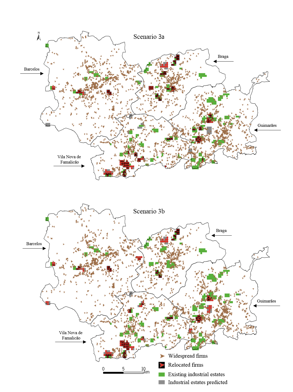
Figure 2. Results of the simulation in scenarios 3a and 3b - 4.8
- Thus, the industrial estates with minimum conditions become attractive when subjected to a qualification; the poorest become unattractive even if qualified. These unattractive estates would rarely be competitive on a sub-regional scale as they are apt to support the local economy where they are installed. In fact, to make these estates attractive, larger investments would be required to overcome the problems related to their location. Moreover, municipalities with more industrial estates scattered around the territory show low efficiency in the adopted policies, because dispersion causes a worse level of accessibility and a lower coverage of facilities and amenities.
- 4.9
- These findings highlight the importance of accurately planning the industrial estates in order to fully accomplish the economic, territorial and environmental requirements for which these were promoted and to avoid additional costs in the future. Thus, the results clearly validate hypothesis 4: promoting dispersed industrial estates with poor-quality infrastructure and amenities is an inefficient policy to attract firms.
- 4.10
- Observing the four hypotheses described above and
particularly the validation of the last hypothesis means that the
paradigm of arbitrarily supplying industrial estates, without
territorial coherence criteria (on the municipal and sub-regional
scales) and without advanced levels of qualification should be
rethought by municipalities. Policies, to be sustainable and effective,
should be properly planned and discussed within the municipality and
with its neighbours. In an urban network, such as this case,
strengthening the coordination of the planning policies is essential to
produce the desired effect and contribute to the development of the
territory as a whole.
Table 4: Main results obtained from the simulated scenarios Indicators Scenario 1 Scenario 2 Scenario 3 3a 3b Number of attractive estates 24 50 33 30 Number of unattractive estates 55 29 53 56 Number of unoccupied lots 404 113 723 500 Number of relocated firms 235 526 694 917
Conclusions
- 5.1
- Planning industrial estates properly is an important issue since it determines the territorial and entrepreneurial competitiveness of the industrial estates. Using appropriate tools is vital to ensure that industrial estates are more efficiently planned. This article describes an agent-based model that was developed as a tool for planning, towards improving the performance of a set of industrial estates located in four municipalities. Agent-based simulation is a tool with growing applications in the planning domain, because it allows dynamic and individual interactions among several territorial entities in a bottom-up approach, highlighting macro patterns that arise from the individual interactions.
- 5.2
- In the developed model, the attractiveness of industrial estates was defined by the level of facilities, amenities, accessibility and by the price of land in each one. The widespread firms with bad location had the purpose of finding a new location in an industrial estate. The new location would have to represent an upgrade in relation to the original place. The relocation process was concluded when a firm would find an industrial estate with vacant lots which has a minimum level of attractiveness. In the model, the attractiveness of the industrial estates can be described as the capacity to attract new firms.
- 5.3
- In this context, the model was developed with the purpose of testing the impact of different policies on the attractiveness of industrial estates on a sub-regional scale. Three scenarios corresponding to different policies were simulated to assess their impact on the capability of industrial estates to attract firms. Policies differ in the level of coordination at which these are implemented by the municipalities and in the type of intervention performed in the estates. The scenarios were also used to validate four hypotheses related with the efficiency of the policies in the attractiveness of industrial estates.
- 5.4
- The results obtained from the model showed that adopting a policy of advanced-quality supply has a positive impact on the performance of industrial estates, improving the number of attractive estates, the number of relocated firms and the number of occupied lots. These benefits encompass both the existing estates, as well as the predicted new sites. In addition, the model demonstrated that if these policies are implemented in a coordinated way, their impact will be greater than if municipalities take their own individual initiatives. Co-ordinating and adopting common planning practices by the four municipalities seems to be essential to strengthen the competitiveness of territories aiming to grow as a network. Furthermore, the model also indicated another important outcome. Despite the general positive effect, adopting a coordinated policy of advanced-quality supply can produce different impacts on a local/municipal/sub-regional scale, as some industrial estates remain unattractive to firms. The simulation showed that the estates with the worst locations and with low coverage of facilities and amenities remain unattractive for firms even if they are upgraded. In this case, the model clearly validated the hypothesis that promoting dispersed industrial estates with poor-quality infrastructure and amenities is an inefficient policy to attract firms.
- 5.5
- The authors believe that these conclusions can be an important contribution to guide planning policies for industrial estates, with the aim of enhancing the territorial and entrepreneurial competitiveness. Despite the specific context of each territory, the authors also believe that this research includes several implications of general interest to other regions and countries that experience similar problems.
Acknowledgements
- The authors would like to thank the Portuguese Foundation for Science and Technology for funding this research (SFRH/BD/48567/2008 grant).
References
- AHRWEILER, P., Pyka, A.
& Gilbert, N. (2004). Simulating knowledge dynamics in
innovation networks (SKIN). In Leombruni and Richiardi (eds.), Industry
and Labour Dynamics: The Agent-Based Computational Economics Approach,
Singapore: World Scientific Press, pp.284–296. [doi:10.1142/9789812702258_0014]
ALBINO, V., Carbonara, N. & Giannoccaro, I. (2003). Coordination mechanisms based on cooperation and competition within Industrial Districts: an agent-based computational approach. Journal of Artificial Societies and Social Simulation 6 (4) 3 <http://www.soc.surrey.ac.uk/jasss/6/4/3.html>.
ALBINO, V., Carbonara, N. & Giannoccaro, I. (2006). Innovation in industrial districts: an agent-based simulation model. International Journal of Production Economics, 104, 30–45. [doi:10.1016/j.ijpe.2004.12.023]
ALTES, W. & Tambach, M. (2008). Municipal strategies for introducing housing on industrial estates as part of compact-city policies in the Netherlands. Cities, 25, 218–229. [doi:10.1016/j.cities.2008.04.005]
BIZUKOJC, E., Bizukojc, M., Marcinkowski, A. & Doniec, A. (2009). The conceptual model of an eco-industrial park based upon ecological relationships. Journal of Cleaner Production, 17(8), 732–741. [doi:10.1016/j.jclepro.2008.11.004]
BODENMANN, B. & Axhausen, K (2010). Synthesis report on the state of the art on firmographics. Unpubished Working paper: Institute for Transport Planning and Systems, ETH Zurich.
BOIX, M., Ludovic, M., Pantel, C. & Domenech, S. (2015). Optimization methods applied to the design of eco-industrial parks: a literature review. Journal of Cleaner Production, 87, 303–317. [doi:10.1016/j.jclepro.2014.09.032]
CAO, K., Feng, X., & Wan, H. (2009). Applying agent-based modeling to the evolution of eco-industrial systems. Ecological Economics, 68, 2868–2876. [doi:10.1016/j.ecolecon.2009.06.009]
CHAN, C., Chow, H., So, S. & Chan, H. (2012). Agent-based flight planning system for enhancing the competitiveness of the air cargo industry. Expert Systems with Applications, 39, 11325–11334. [doi:10.1016/j.eswa.2012.02.031]
CROOKS, A. (2010). Using geo-spatial agent-based models for studying cities. Working Paper Series 160: Centre For Advanced Spatial Analysis.
DE BOK, M. (2007). Infrastructure and firm dynamics: a micro-simulation approach. Unpubished PhD Thesis: Delft University of Technology.
FERNÁNDEZ, I. & Ruiz, M. (2009). Descriptive model and evaluation system to locate sustainable industrial areas. Journal of Cleaner Production, 17, 87–100. [doi:10.1016/j.jclepro.2008.02.011]
FIORETTI, G. (2006). Agent-based models of industrial clusters and districts. In Tavidze, A. (ed.), Progress in Economics Research (pp.125–142). New York: Nova Science Publishers.
FONSECA, F. & Ramos, R. (2010). The adoption of a regulatory framework for industrial parks network in the Ave valley, Portugal. European Network on Industrial Policy International Conference, 9–11 June, Reus.
FORGET, P., D'Amours, S. & Frayret, J. (2008). Multi-behavior agent model for planning in supply chains: an application to the lumber industry. Robotics and Computer-Integrated Manufacturing, 24, 664–679. [doi:10.1016/j.rcim.2007.09.004]
GAO, Y., Shang, Z. & Kokossis, A. (2009). Agent-based intelligent system development for decision support in chemical process industry. Expert Systems with Applications, 36, 11099–11107. [doi:10.1016/j.eswa.2009.02.078]
GIARDINI, F., Tosto, G. & Conte, R. (2008). A model for simulating reputation dynamics in industrial districts. Simulation Modelling Practice and Theory, 16, 231–241. [doi:10.1016/j.simpat.2007.11.017]
GILBERT, N. (2008). Agent-based models, quantitative applications in the social sciences, Thousands Oaks: Sage Publications.
JENNINGS, N. & Wooldridge, M. (1998). Applications of intelligent agents. In Jennings, N., Wooldridge, M. (eds.), Agent Technology: Foundations, Applications and Markets, Springer-Verlag, pp. 3–28. [doi:10.1007/978-3-662-03678-5_1]
KHAN, A. (2002). A system for microsimulating business establishments: analysis, design and results. Unpubished PhD Thesis: University of Calgary.
KRABBEN, E. & Buitelaar, E. (2011). Industrial land and property markets: market processes, market institutions and market outcomes: the Dutch case. European Planning Studies, 19 (12), 2127–2146. [doi:10.1080/09654313.2011.633822]
KUMAR, S. & Kockelman, K. (2008). Tracking the size, location and interactions of businesses: microsimulation of firm behavior in Austin, Texas. In Proceedings of the 87th Annual Meeting of the Transportation Research Board. Washington D.C. [doi:10.3141/2077-15]
LEVY, S., Martens, K. & Heijden, R. (2011). An agent-based model of transport and land use policy coordination between municipalities. In Proceedings of the Bijdrage aan het Colloquium Vervoersplanologisch Speurwerk. Antwerpen.
MANZATO, G., Arentze, T., Timmermans, H. & Ettema, D. (2010). A support system that delineates location-choice sets for firms seeking office space. Applied GIS, 6 (1), 1–17.
MANZATO, G., Arentze, T., Timmermans, H. & Ettema, D. (2011). Exploring location influences on firm survival rates using parametric duration models. In H.J.P. Timmermans & B. de Vries (Eds.), 10th International Conference on Design and Decision Support Systems in Architecture and Urban Planning, (pp. 1–16). Eindhoven: Design and Decision Support Systems Research School.
MANZATO, G. (2012). Modeling office firm dynamics in an agent-based micro simulation framework. Eindhoven University Press: Eindhoven.
MAOH, H. & Kanaroglou, P. (2005). Agent-based firmographic models: a simulation framework for the city of Hamilton. In Proceedings of the Second International Colloquium on the Behavioural Foundations of Integrated Land-use and Transportation Models: Frameworks, Models and Applications. Toronto.
MAOH, H. & Kanaroglou, P. (2009). Location of business establishments: a micro-analytical model for the city of Hamilton in Ontario, Canada. Transportation Research Record: Journal of the Transportation Research Board, 2133, 33–45. [doi:10.3141/2133-04]
MATTHEWS, R., Gilbert, N., Roach, A., Polhill, J. & Gotts, N. (2007). Agent-based land-use models: a review of applications. Landscape Ecology, 22, 1447–1459. [doi:10.1007/s10980-007-9135-1]
MAZZAROL, T., Cresp, D., Mcfarlane, R. & Edlinger, E. (2009). Industrial Land Development in Western Australia Stage 1 Report: A Review of Global Trends, Innovation and Best Practice. Perth: JMG Marketing.
MILLER, E., Hunt, J. & Abraham, J. (2004). Microsimulating urban systems. Computers, Environment and Urban Systems, 28, 9–44. [doi:10.1016/S0198-9715(02)00044-3]
MOECKEL, R., Spiekermann, K., Schürmann, C. & Wegener, M. (2003). Microsimulation of land use. International Journal of Urban Sciences, 7(1), 14–31. [doi:10.1080/12265934.2003.9693520]
OTTER, H., Veen, A. & Vriend, H. (2001). ABLOoM: location behaviour, spatial patterns, and agent-based modelling. Journal of Artificial Societies and Social Simulation, 4 (4) <http://www.soc.surrey.ac.uk/jasss/4/4/2.html>.
PABLO, C., Domínguez, T. & Alén, E. (2013). An empirical analysis of horizontal differentiation of Galician industrial estates. Investigaciones Europeas de Dirección y Economía de la Empresa, 19, 169–179.
PUENTE, M., Diego, I., María, J., Hernando, M. & Hernáez, P. (2007). The development of a new methodology based on GIS and fuzzy logic to locate sustainable industrial areas. 10th AGILE International Conference on Geographic Information Science 2007, Aalborg University, Denmark.
RAMOS, R. & Mendes, J. (2001). Avaliação da aptidão do solo para localização industrial: o caso de Valença. Engenharia Civil, 10, 7–29.
RIKALOVIC, A., Cosic, I. & Lazarevic, D. (2014). GIS Based Multi-Criteria Analysis for Industrial Site Selection. Procedia Engineering, 69, 1054–1063. [doi:10.1016/j.proeng.2014.03.090]
RUIZ, M., Romero, E., Pérez, M. & Fernández, I. (2012). Development and application of a multi-criteria spatial decision support system for planning sustainable industrial areas in Northern Spain. Automation in Construction, 22, 320–333. [doi:10.1016/j.autcon.2011.09.009]
SCOTT, P. (2001). Industrial estates and British industrial development, 1897–1939. Business History, 43 (2), 73–98. [doi:10.1080/713999223]
SILVA, M., Almeida, A. & Silva, S. (2008). Plano de acção para a promoção do acolhimento empresarial no Norte de Portugal 2008–2010, CCDRN, Porto.
SP – Statistics Portugal (2011). Integrated Business Accounts System. Unpublished data base: INE.
SQUAZZONI, F. & Boero, R. (2002). Economic performance, inter-firm relations and local institutional engineering in a computational prototype of industrial districts. Journal of Artificial Societies and Social Simulation, 5 (1) 1 <http://www.soc.surrey.ac.uk/jasss/5/1/1.html>.
TIMMERMANS, H. (2003). The saga of integrated land use-transport modelling: how many more dreams before we wake up. In Axhausen, K. (ed.), Moving through nets: the physical and social dimensions of travel (pp. 219–248). Oxford: Elsevier.
UDAYAKUMAR, M. (2010). The impact of industrial park on the industrial and economic growth of Tamil Nadu: a study with reference to the industrial parks developed by SIPCOT. Unpubished PhD Thesis: Pondicherry University.
WADDELL, P. (2002). URBANSIM: Modeling Urban Development for Land Use, Transportation, and Environmental Planning. Journal of the American Planning Association, 68 (3), 297–314. [doi:10.1080/01944360208976274]
WISSEN, L. (2000). A micro-simulation model of firms: applications of concepts of the demography of the firm. Papers in Regional Science, 79(2), 111–134. [doi:10.1007/s101100050039]