© Copyright JASSS

  JASSS logo ----

Patrick D'Aquino, Christophe Le Page, François Bousquet and Alassane Bah (2003)

Using Self-Designed Role-Playing Games and a Multi-Agent System to Empower a Local Decision-Making Process for Land Use Management: The SelfCormas Experiment in Senegal

Journal of Artificial Societies and Social Simulation vol. 6, no. 3
<https://www.jasss.org/6/3/5.html>

To cite articles published in the Journal of Artificial Societies and Social Simulation, please reference the above information and include paragraph numbers if necessary

Received: 30-Mar-2003      Accepted: 22-Jun-2003      Published: 30-Jun-2003


* Abstract

As agricultural and environmental issues are more and more inter-linked, the increasing multiplicity of stakeholders, with differing and often conflicting land use representations and strategies, underlines the need for innovative methods and tools to support their coordination, mediation and negotiation processes aiming at an improved, more decentralized and integrated natural resources management. But how can technology fit best with such a novel means of support? Even the present participatory modeling method is not really designed to avoid this technocratic drift and encourage the empowerment of stakeholders in the land use planning process. In fact, to truly integrate people and principals in the decision-making process of land use management and planning, information technology should not only support a mere access to information but also help people to participate fully in its design, process and usage. That means allow people to use the modeling support not to provide solutions, but to help people to steer their course within an incremental, iterative, and shared decision-making process. To this end, since 1997 we have experimented at an operational level (2500 km2) in the Senegal River valley a Self-Design Method that places modeling tools at stakeholders' and principals' disposal, right from the initial stages. The experiment presented here links Multi-Agent Systems and Role-Playing Games within a self-design and use process. The main objective was to test direct modeling design of these tools by stakeholders, with as little prior design work by the modeler as possible. This "self-design" experiment was organized in the form of participatory workshops which has led on discussions, appraisals, and decisions about planning land use management, already applied two years after the first workshops.

Keywords:
Agent Based Modeling; Land Use; Local Planning; Participatory; Resources Management; Role Playing Games

* I. A novel form of a Role-Playing Game to accompany a collective decision-making process in land use management.

1.1
Role-Playing Games (RPGs) have already been used to support land use management (Commere 1989, Mermet 1991and 1993, Piveteau 1994, Barreteau et al. 2001). The games, which depend upon the prior diagnosis of the situation by experts, help players to share in this analysis and to draw upon some improvements based on it. But in our own experiment, we use a decidedly different form of RPG: a Self-Designed RPG. There are no prior rules and the setting of the game is drawn from our own previous diagnosis. The RPG is designed solely from a self-analysis of the players' situation and is produced in a single step.

1.2
This type of RPG inevitably relies upon very simplified rules and a crude game setting. But the goal is not to conceive a game that is technologically advanced and satisfying from our own expert point of view. Our purpose is to create a novel design that includes "mediating supports" (Boltanski and Thévenot 1991), which could facilitate the emergence of worthwhile debates by taking into account all the different perspectives and building upon some truly common technical devices (D'Aquino et al. 2001 et 2002). The method seeks to help people to progressively formalize the elements-as they move forward through their debates-which appear useful to all for the improvement of their decision-making abilities. In fact, the usual technical complexity that designers often put into a RPG designed to support negotiation is due to the designers' need to reproduce any possible impact, especially an environmental impact, of the interactions among any players. This type of designer's RPG must take into account all the potential dynamics and effects between the environmental and socio-economic elements in order to help decision-makers find the best solution. This sort of designer instinctively contrives the whole process in the form of a perfect decision being located in a given time frame (the game's time), as opposed to the realistically complex situation that he should attempt to reflect in his RPG. His tacit hypothesis is that all the essential elements for the decision can be selected prior to the game and then deposited in the RPG. In fact, even if there is minimal participation by the people affected, this sort of formalized modeling is always a personal endeavor of the designer; all the more so since a major concern for the designer is often the collection of a maximum amount of diverse data for carrying out an analysis that will be as close as possible to reality. Yet this entire process infers that the goal is to produce a tool that will be able to guarantee to the decision-makers its conformity with their reality. The risk lies in the difficulty of reaching a model sufficiently close to the complex nature of reality without producing a device that is so intricate that it is no longer suitable to use efficiently. The possible weaknesses of this model lie in the ambiguous nature of the designing expert, who often positions himself as the master of the decision process. Many information systems fall into these traps.

1.3
From the outset, we believe the decision-making process is primarily a continuous, iterative and incremental process. So the purpose of an effective tool of this type cannot be to produce right decisions but to help people to steer the process towards less imperfect decisions.Hence, the degree of complexity of the decision-making tools should mirror the progressive, continuous and iterative nature of the decision-making process, and this is the first challenge in the creation of support tools.

1.4
Consequently, in this paper we tackle the design of decision-making tools in a different manner. Contrary to G.D. Brewer (1985), we do not believe that fostering the internal representation of the complexity involved has a lower operational value than classical experts' analyses. First, this internal construction will enhance the use of tools. Secondly, the tool will be most efficient when its design speaks closely to the "real matter" (i.e., the matter such as it appears to decision-makers), than when its design addresses the "environmental matter" (i.e., the matter such as it appears to exogenous people). What is the progress in decision-making in this case? The improvement in the process depends upon providing common supports that help decision-makers in their internal debate and learning-by-doing approach. We believe that the main constraint in land use management issues is not dependent upon technical advice or knowledge but in the efficiency of the socio-political dynamic of debate, decision and action. A collective, effective, and sustainable socio-political process, in which tools merely serve the interests of stakeholders and their representatives, is necessary for tackling land use management. The first aim of our supportive tools is to accompany the decision-makers in their own iterative and progressive route towards a common perception, then decision, concerning the complex matters they face.

1.5
All this leads to our self-design principle (D'Aquino et al. 2001 and 2002): the more endogenous the design is, the more appropriate the tool is. The challenge is therefore to conceive of a methodological framework that places at the disposal of the stakeholders and others principals all relevant knowledge and information so that they themselves can manage their issues. Expert knowledge and appropriate information may thus be summoned up progressively by the principals upon their own request and within the context of their own objectives. That is, tools able to (i) take into account their own perceptions; (ii) put advisers' knowledge at their disposal; (iii) be directly controllable by them. This is how we experimented in Northern Senegal.

1.6
In Senegal, our team, along with the local principals, is focused on tackling multipurpose land use management issues and solving the puzzle of sustainable development. Our aim is to help these principals to progress towards an improved self-management, especially by vigorously involving the stakeholders. In other words, this experiment has engaged our above-mentioned hypotheses in a practical way: taking into account people's own perceptions, putting external knowledge at their disposal, and encouraging the direct supervision of every step by them. Accordingly, we have tested a methodology for the shared collective design of planning supports that will help the local principals enhance their empowerment in planning decisions regarding sustainable land use management. The Senegal River Valley is located in a very dry area, and water and other renewable resource uses involve strained competitions. Agriculture and breeding relationships are especially tricky, intermingling land tenure and water access issues with multiple uses of the vegetation. Moreover, as in many countries, decentralization policies have transferred to communities the responsibility of coping with these problems, whereas the State and its partners had never been successful in managing them. Communities then ask for support to help them deal with the various parties competing for land use.

* Accompanying the self-design of an RPG for common land use management.

2.1
The aim of the experiment is to test the use of RPG and MAS to help local principals enhance and improve their planning discussions and decisions about land use management. It involved a pilot project[1] iin which local community representatives and public institutions were brought together in order to test new supports that were better suited to the community needs in the context of the decentralization policies. We experimented with these uses in difficult local situations where a tricky problem blocked collective land use management. In fact, the local community members themselves identify the local situations for which they think some new approaches are needed to help them. The "self-design" experiments were organized in the form of discussion workshops for a primary land use scale of around 2,500 km2 and 40,000 people[2] (see the three sites in figure 1).

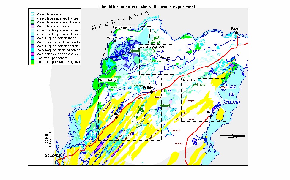
Figure 1. The different sites of SelfCormas experiment

2.2
Several workshops were organized within a one-year period by the rural council of the local community of Ross-Béthio in Senegal, a local partner that volunteered for this experiment. The modeling workshops were lead by a member of the research team. The first step in our method is the identification and subsequent acknowledgment[3] by the participants (stakeholders, representatives and principals) of (i) the kinds of stakeholders they think it is important to take into account, as regards the subject of the workshop[4]; (ii) the satisfaction criteria for these various kinds of stakeholders. The satisfaction criteria have been explained to players as "the fundamental elements necessary for every stakeholder to succeed in providing a living for his family". And we ask the players to define these fundamental elements for each type of stakeholder. This sort of "gentlemen's agreement" is essential; it allows shifting the analysis towards elements that no one would contest and disposing of conflicting matters by harking back to the deeper incentives underlying them.

2.3
For instance, in the first experiment[5], participants had decided to propose farmers, breeders, fishermen, hunters and National Park as possible subjects in the workshop. Then, they defined their satisfaction criteria:
  • Farmers needed a spring nearby, not more than 500 m. away, and a piece of land not liable to flooding.
  • Breeders needed an access to a fresh watering place nearby, not more than 800 m. from grasslands; and the grasslands, which should be no more than 800 m. from stations, should flood every year but not for more than 20 days.
  • Fishermen needed a flood zone not more than 800 m. from every settlement and fitting certain conditions (with and without vegetation, different times of flooding, etc.).
  • Hunters (wild geese and ducks) needed a flooded zone until March (i.e., for six months).
  • The needs of parks are represented by the needs of its main residents: wetlands migratory birds. These fowl have been deemed to need various watering zones (with and without vegetation, shallow and deep places, etc.) free from disturbance by the closest human residents.

2.4
The second step of our method consists of identifying over the course of time, throughout the entire year, the same satisfaction criteria for each activity. One can see a demonstration of this step in the chart in 1.

Table 1. The pointing out of the diachronic stakes for multi-purpose uses of natural resources; Example of Djoudj Workshop

2.5
This detailed synopsis is the kind of highly detailed support that encourages the formation of an accurate common representation of the matter and therefore an operationally successful decision process. Nonetheless, it is a self-designed chart, designed and filled out solely by participants, i.e., the stakeholders and their principals.

2.6
This common acknowledgment is a real collective initialization of the individual situations of all types of stakeholders, their incentives, their constraints and their difficulties. This shared knowledge and agreement taken together are the first stepping-stones we reach, and provide a solid footing for the future success of the decision-making process. No external input, no technical knowledge, no expert advice: merely information perhaps already known by every participant but not yet communally constructed in a public arena and presented without arousing resentment at anyone's behavior or actions. This is the goal of the first phase of our method: an endogenous construction of a situation sufficiently close to actual circumstances to design a RPG that will let us to examine the space and time compatibilities among the different land uses. When discussions between stakeholders are blocked and characterized by deep conflict, the RPG is beneficial for setting a non-conflicting reality in motion : that pre-conflict reality in which people are willing to discuss.

2.7
During the "Gnith" workshop (see location figure 1), participants defined only two types of stakeholders (breeder and farmer) that were relevant to the main question on which they had agreed to focus: competition between agriculture and breeding. Then, they distinguished several types of lands/resources[6]. We do not ask for a global point of view about their environment, but only a list of places/resources/other elements important for each type of stakeholder. Next, we ask them to rank the quality of these places, as regards the different uses identified, with school grades (based on a scale of one to ten, with ten being

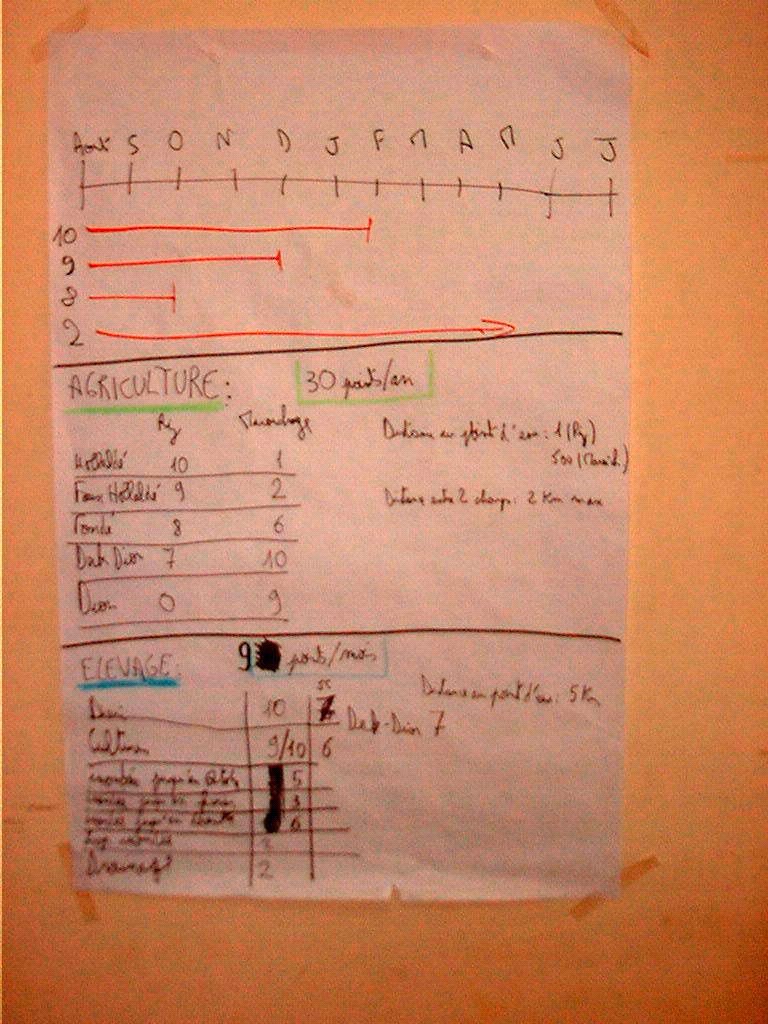
Table 2: "Best place" for agriculture as defined by stakeholders during the "Gnith" workshop.

SoilRice cultureGardening
False hollaldé (vertic soil)92
Hollaldé (clayey)101
Fondé (silt and clayey)86
Deck (sandy and clayey)73
Deck dior (silt and sandy)710
Dior (sandy)09

2.8
The goal of the second phase is to then allow participants to "set in motion", and therefore to test, their first common representation of the land use management issue that had previously been taken up. The self-designed RPG becomes this "setting in motion", in which every stakeholder previously described is one of the characters. Indeed, as seen in the preceding chart, one notes that, during the participatory analysis, people select not only spatial and temporal information about land uses, but also the types of stakeholders they believed it was important to take into account (fisherman, farmer, breeder, etc.). For every stakeholder, participants identified the resource needs of each type, including the matter of distance, for example. We were then able to organize a RPG from these elements to help participants to simulate the scenario that they had previously designed: a self-designed role-playing game, i.e., a RPG designed solely through the process of their own analysis. The different types of stakeholders selected by participants were the players of the game and the pertinent elements were merely drawn from their previous debates and used as a framework for the game; its basic rules were drawn from the elements discussed during the first stage (see table 1 and figure 2), and its cartographic support was derived from geographical databases (from a regional GIS) that were organized according to these elements.

Figure 2. Letting people put a value into time and space on every natural resources previously picked out; Example of Gnith Workshop

2.9
Each player must attempt to satisfy the needs required by his character throughout the yearly cycle. Hence, month after month in this game, each player decided on his activity and his position, according to a definition of his requirements, which were previously established jointly. The scores given in the tables above for each type of resource led to a rough quantification of these requirements.

2.10
For instance, in the case of the first workshop ("Djoudj site"), the set-up of the game was as follows:

  1. The cartographic support (see figure 3) enlisted use of the previous endogenous legend from the first steps (see legend in figure 1) and used a GIS to fill out the map; two irrigation canals have been added, to reconstruct a truly typical situation. This cartographic support was divided roughly equally into compartments for more convenient linkage between users and resources.

    Figure 3. The setting of the game : a map from a self-designed legend

  2. To show his position at each time interval (one month), each player used a sticky note as a token. At each time-step, a player moved his sticky note around the map. Six types of user tokens were distributed among 13 players: 4 farmers, 1 small breeder, 2 large breeders, 2 fishermen, 1 hunter, and 3 migratory birds (see figure 4).

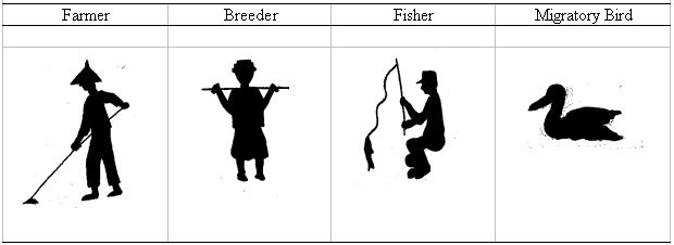
    Figure 4. Stakeholder figurines chosen and then used by participants in "Djoudj" Workshop.

  3. At the beginning of the game, each participant drew lots for a character (in fact, a type of resource user), but no participant could play the character he was in reality.
  4. "Sanctions" were given to players who had not succeeded in satisfying the needs of their characters. A drawing of a crying woman, symbolizing a family in need, depicted this tion (see figure 5).

    Figure 5
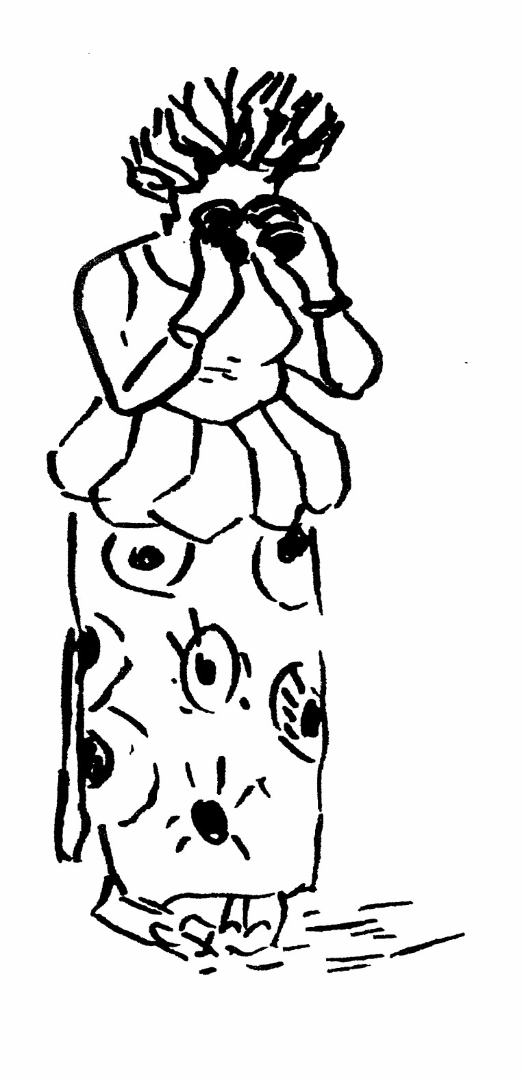
    Figure 5. The "Sanction" figurine, used when the needs remained unsatisfied during a yearly cycle.

  5. A single turn in the game lasted one month, and the game itself began after the rainy seasended (October). Every player moved his character on the map as he wished at each turn. Then afterwards, when the scoring of the game occurred (see just below), if adequate resources existed at the spot, the user would be considered satisfied.
  6. At the end of the yearly cycle, participants publicly took stock of the sanctions and "fines" (when a player did not respect a rule) for each player. Then, one after the other, each player explained the motives for his behavior and the difficulties encountered during the recently past cycle. This is an enormously important step, which allows a common and shared analysis of the various interactions and their effects upon the current situation, always taking care not to pinpoint the responsibility or guilt of any particular player.
  7. From this analysis, players identified some likely paths towards possible solutions (rules, infrastructure, etc.), which they next tested by playing new cycles of the game.

2.11
At the beginning of the game, each player settles his token on the map, according to the key incentives they had established beforehand: for instance, if they established as important the distance between their homes and some key places (resources, crops, etc.), they begin by locating their homes. Then, each player indicates on the map, by means of sticky notes, where he decides to locate his rangelands, crops, etc. Afterwards, at each step of the game, each player shifts his personal sticky note indicating his mobile activities (e.g. herds or wildlife movements), according to the key elements set up in previous steps (e.g.. resource value, water distance...).

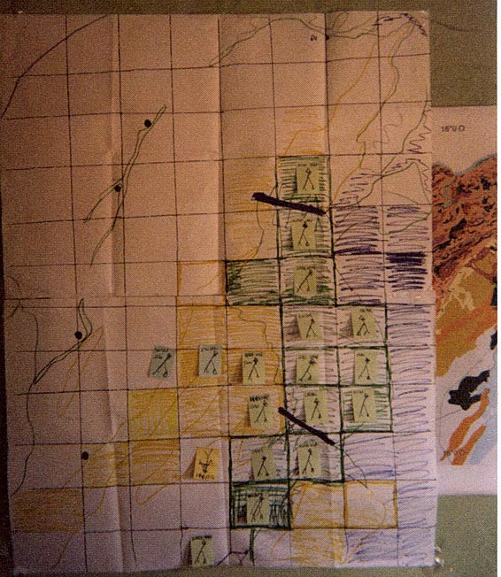
Figure 6. Setting of the "Gnith" RPG with the sticky notes representing the different players.

2.12
The first yearly cycle is used to rectify and validate every participant's understanding and evoke some acknowledgment of other stakeholders' needs and constraints. This first session thus validates in an explicitly public fashion the acknowledgment of the crucial stakes of the situation, detailing competition among uses and the incompatibilities discovered in a realistically operational manner. The seasons, environmental factors (the degree of flooding, for example) and the locations involved are all taken into account. Afterwards, subsequent sessions lead to productive debate that helps participants imagine together solutions that do not somehow punish the "bad conduct" of some stakeholders, but instead increase everybody's satisfaction. One of the great effects of this kind of self-design process is that people are induced to believe that solutions that are good for everybody are perhaps possible by implementing new rules or infrastructure arrangements. Participants also come to realize that some of the negative aspects of a given situation are not necessarily due to a specific user but were perhaps caused by some elements that simply did not function well together. Here we may again touch upon our main hypothesis: the first constraint to the improvement of land and natural resource use management lies more often in socio-political dynamics than in technical progress.

2.13
It is worth noting that participants quickly understood the logic of the RPG as well as the needs and incentives of each stakeholder. Take for instance the "conflict" that broke out at the game's very first turn between a Park official playing a breeder and a local politician playing a farmer-a type of conflict that is very frequent in this area ( D'Aquino et al.1999, D'Aquino and Seck 2002). The Park official, playing a breeder, decided to stealthily let his animals graze in the Park (strictly forbidden) to satisfy the needs of his herd, then tried to (unsuccessfully) negotiate access to the Park with his true superior in real life. In the same way, three peasants playing migratory birds quickly grew to know the needs of wildlife, quietness, for example. After the offenses they committed in the first cycle, before they understood the needs of the birds, these peasants were heavily penalized. The peasants eventually came to be the least penalized. And lastly, a hot debate brought Park officials into conflict during the ending assessment. On one side were those who had played farmers and had defended agricultural interests seen as attacked by breeding interests, on the other side were those who had played breeders and had defended the opposite point of view. All this occurred in front of real breeders and farmers, who were quite interested in this turn of events since they themselves had never succeeded in making Park officials agree that these foraging and cropping difficulties existed in the outlying zones of the Park.

2.14
Throughout these debates an implicit and healthy testing of the rules and infrastructures led every participant in the subsequent game sessions to clearly point out the two main causes of difficulties in this case: the lack of good rangelands (flooded for at most two months) because of the Park's and the farmers' unwillingness to resolve the issue of grazing after crops were harvested. Every participant himself acknowledged this analysis, even the Park officials and farmers. Hence, debates no longer fruitlessly attempted to place responsibility and guilt but instead tried to uncover the means ("how?") for handling these matters. This culminated in novel and operationally successful agreements and proposals (see table 3).

Table 3: "Best place" for breeding as defined by stakeholders during the "Gnith" workshop.

LocationRainy Season Beginning of Dry SeasonAfter crops
Diéri (sandy)1010
(if less than 5 km from a watering place)
10
(if less than 5 km from a watering place)

Irrigated crops

inaccessible
(under cultivation)

inaccessible
(under cultivation)

9

Temporarily flooded
zones

inaccessible
(water)

inaccessible
(water)

Between 2 and 10
(according to the duration of flooding)

Drainage zones

inaccessible
(water)

inaccessible
(water)

2

Shore of Guiers lake

inaccessible
(under cultivation)

inaccessible
(under cultivation)

6

2.15
This type of result was very new in this place where heated tensions existed between breeders and farmers, and between peasants and the Park's administration as well.

2.16
At this point the collective progress led people into deeper dialogues that culminated in more accurate planning. Participants finally asked for more convenient forms of accompanying, especially by including in the mix the dynamic effects of interactions between the different uses and the medium-term evolutions. We provided them with the necessary supports for a simulation process involving RPG and MAS modeling. This is the second step of our approach.

* Next, the self-design of MAS modeling.

3.1
Among the range of modeling tools available, Multi-Agent Systems (MAS) seem to be particularly suitable. For several years, Multi-Agent Systems have been used in the field of natural and renewable resource management. Our team has designed a special MAS platform, CORMAS (COmmon-pool Resources and Multi-Agent Systems) that greatly simplifies the task of modeling and simulation ( Bousquet et al.1998, Bousquet et al.1999), and is used for knowledge integration in the collective learning processes that focus on integrated natural resource management issues. Before the SelfCormas experiment, the Cormas platform proposed a very schematic display of the agents located on the spatial grid of the model, using simple polygons. The user had only the possibility of selecting the number of sides to make a triangle, a diamond, or a hexagon. For the SelfCormas experiment, in order to make a direct mapping of the sticks used during the role-playing game into agents moving on the computer screen, we have introduced the possibility of editing images with more representative shapes. This feature has been generically set into the simulation platform. Other examples of features specially designed for the SelfCormas experiment that were later integrated into the kernel of the simulation platform are (i) the possibility of encoding access rules defined for a given activity during an interval of time (initial and final time-steps) by mouse-clicking in any cell of the spatial grid, (ii) the possibility of adding or removing objects located in any cell of the spatial grid by mouse-clicking. In the SelfCormas experiment, the first one has been used to assign restricted access during the wet or dry season, and the second one has been used to add new water points or to design channels.

3.2
Three three-day workshops were organized for the first MAS self-design tests. Around twenty-five people attended each of the workshops. RPG and MAS are particularly well suited to complex situations and prospective studies, being themselves complex systems involving random and somewhat unpredictable dynamics. Actually, RPGs are themselves models of real situations, and they are much closer to reality and easier for people to use than computer modeling. However, RPGs are often rather cumbersome at the operational level and for providing continuous support in an ongoing decision-making process. Moreover, RPGs do not allow for a sufficiently incremental and iterative process that progressively integrates information and knowledge. Therefore, we used RPGs as a kind of interface between computer modeling (GIS and MAS) and people (users, stakeholders, policy makers and field experts), thus allowing them to participate in the design of the model as well as facilitating their own use of the simulations ( Barreteau and Bousquet 2000, Bousquet et al.2001, Barreteau et al.2001, Boissau and Castella 2001, Bousquet et al. 2002)viii. RPGs are thus able to simulate scenarios that are imagined by participants and to generate group discussion of possible interactions between users and resources. Whereas GIS allows for a more complex integration of information, and MAS explores more rapidly and systematically the richer and more incremental processes and controls involved, RPGs are useful for supporting dialogues between people and computer models. Based on this reasoning, in the following SelfCormas experiments we have tested RPG as a progressive way of designing novel computer models (GIS and MAS) that are more suitable for resolving the issues and perceptions of the people involved.

3.3
Exhausted by long game sessions, people eventually come to ask for a more convenient form of support. Computer modeling (for us, the RPG is itself a model) then becomes worthwhile. Thus we accompany players (following a companion modeling approach called "ComMod") towards a CORMAS platform that adopts the previous role-playing game model: a self-designed MAS.The same setting of the game, the same GIS maps, and the same crude rules designed by participants are transferred from the game into a MAS model.

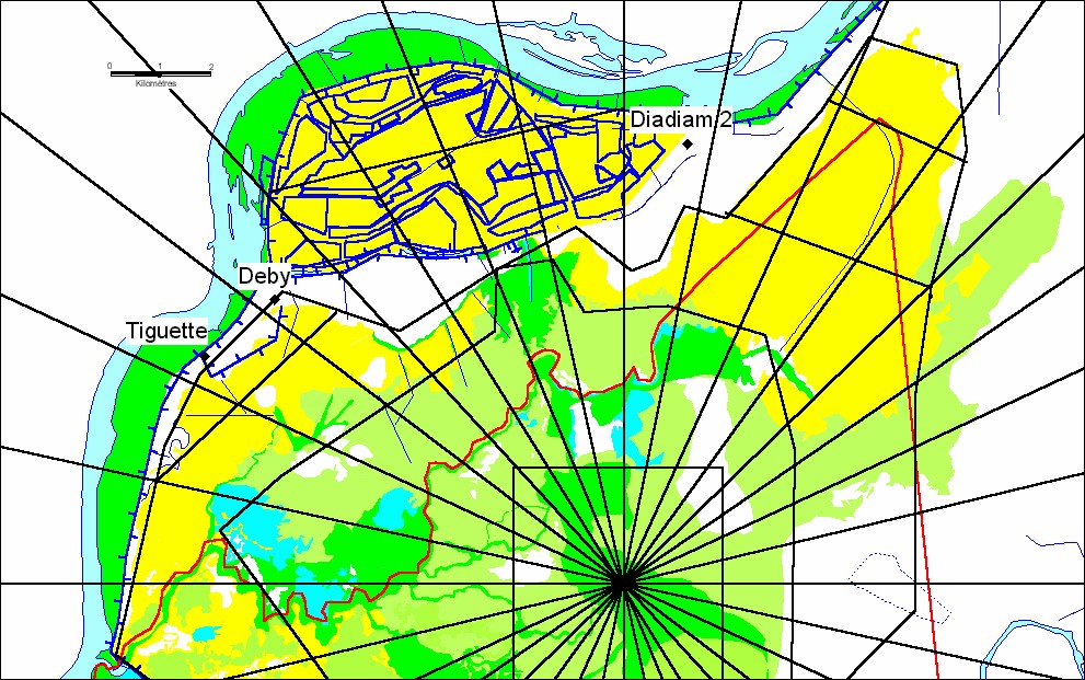
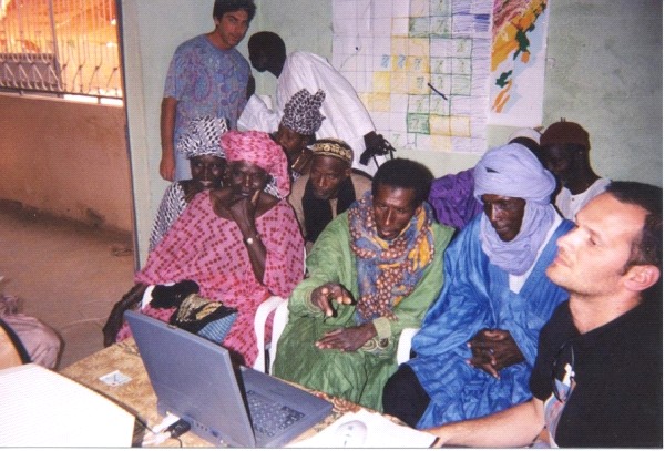
Figure 7. Gnith workshop. The use of a GIS to fill the self-designed maps

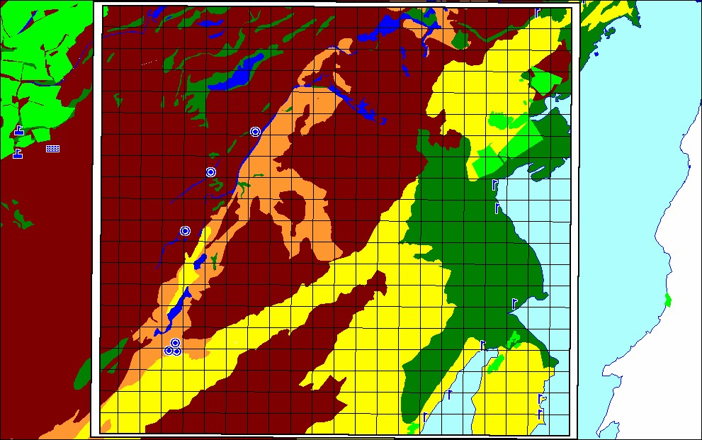
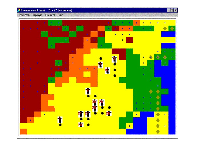
Figure 8. A view of the Cormas spatial grid for the Gnith ABM. The figurines show the locations of agents at the current time-step, black dots represent crop fields, olive diamonds represent residuals from previous crop fields, small blue dots represent water points

3.4
Figures 6, 7 and 8 illustrate (case of the Gnith workshop) the process of building the spatial grid of the ABM (figure 8) by using the same kind of information available from a GIS (figure 7) used to design the board of the RPG (see figure 6).

3.5
Our objective is to test a self-designed MAS requiring modelers to concentrate on producing an upstream modeling environment, rather than a real model, involving as little prior design work by the modeler as possible and enabling stakeholders to express themselves right from the initial stages in the design of their own model. In fact, in our previous self-designed RPG modelers, who attended the RPG as mere spectators of the discussions, had transcribed the crude rules of the RPG into a MAS model. They had also amended the platform so that the model could test the kinds of changes and regulatory scenarios imagined by participants. Thus, the multi-agent model corresponding to the RPG was programmed from the self-designed RPG. In other words, we let people construct and then test a model through a RPG before providing them with a computer-modeling platform.

3.6
Since this flexibility in CORMAS allows us to model the previous RPG features exactly, participants have no problem understanding the MAS model, and they immediately launch into simulation. By progressing gradually over a short time, the stakeholders learn to follow the different scenarios on the screen, discuss them and propose new ones. After playing out the scenario identified in the previous RPG, new situations emerge, are simulated and then discussed. This provides an opportunity for testing the sensitivity of a given set of collective rules and their consequences with respect to the shared set of assumptions already involved in the behavior of the individual stakeholders. Hot debates may often emerge and demonstrate the worth of these tools for the improvement of the collective processes that we hope to foster (see figure 9).

Figure 9. Gnith workshop. Hot debates from RPG then MAS, even with people lacks of formal education

3.7
We strive to keep open additional possibilities for going further than we do with the game sessions alone. This approach has been used at land use scales from a few hundred square kilometers to 2,500 km” during the same time period. In fact, all this flexibility leads to an incremental, progressive and iterative set of supports to accompany the complex issues of land use and self-management. In our experiments, the model has grown progressively richer at the same rate as has the collective decision-making process, thanks to its use in different situations and at different scales as well as its ongoing progress at a given site. Our incremental and bottom-up accompaniment has always fostered increasing progress towards ever more complex forms of self-government.

* Conclusions and perspectives.

4.1
Developing RPG in conjunction with GIS and MAS is an effective and valuable way of transferring a large measure of the hands-on power to the users. It would have been physically impossible without computer simulation to play out the different scenarios selected by the stakeholders and to observe their multiple impacts over sufficiently long time intervals. A modeling platform that is flexible enough offers many more possibilities for modifying the rules on demand than do cumbersome game or workshop sessions. The participants were themselves the initial designers of the models, and they were entirely aware of the gap between themselves and reality. Focusing on dynamics instead of results (MAS), and focusing on wide-ranging analysis instead of quantitative data (GIS), are the primary ways in which modeling results should be used. Having largely designed the model, participants were well aware that it was not a "magic" black box capable of seeing into the future. Thanks to the self-design aspect of the project, participants became capable of having more and more insights into the results of the simulations. The stakeholders who developed and played the game were fully capable of interpreting the results of the model and linking them with reality. Even the high rate of illiteracy and lack of formal education among the participants were not obstacles to the use of computer simulations with this method. Moreover, there has been no need for the use of sophisticated agents in order for the main land and resource management problems to easily emerge in the simulations. Since the stakeholders themselves instigated the simplifications, they reflect the most important aspects of their actual behavior. Simulation thus multiplies the effectiveness of collective and participatory thinking and is able to take the decision-making process much further. Currently, we envision the use of computer modeling as a group-decision support tool that will improve negotiation.

4.2
Last but not least as regards our objectives, our experiments enabled new progress to be made in negotiations in a thoroughly conflict-laden local context. Since our experiments, many practical achievements in regional planning have been inspired from the use of these supports ( D'Aquino et al. 1999, D'Aquino and Seck 2002). For instance, in one of the experiments, the establishment of protected rangelands, previously a taboo subject, was debated, and a decision was even made to ask the local technical services to talk about the possibilities of improving rangeland yield in these new protected areas. In another area where the problem was access to water, simulation resulted in an agreement on new collective regulations that allowed water access for all activities. This process also begins to change the behavior of local stakeholders and principals with respect to their technical partners. Thanks to this supportive modeling becoming both an endogenous activity as well as a technically valuable one, the representatives of local populations themselves identified the technical advice they required within their decision-making process (information on rangeland development, appraisals of certain crops on sandy soils, etc.), and then they directly contacted the technical services to satisfy their needs. Thus, self-design methods allowed participants (whether stakeholders, principals, or local politicians) to progressively handle all these tools in a more empowered manner in the sphere of local land use management. Two years after the first experiment, the enforcement of several decisions has been significantly improved. The community has on its own achieved two new types of irrigated schemes[8] that were defined within the MAS simulations; some lands have been reserved for livestock activities, and some areas have been strictly forbidden for livestock.

4.3
Aside from these great achievements, however, it is difficult to identify what are the direct practical applications stemming from the modeling workshops. In fact, the initial objective of our experiments is not to directly produce practical applications but to start an autonomous progress towards shared collective decisions and, only then, applications. In fact, modeling and decision tools work on only a part of the enforcing process, namely the interactions between decision-makers during the decision act. But in land use management issues, the enforcing process is such a social, institutional and political matter that the interaction between decision-makers is only a part of the enforcing process. We do not think the enforcing process could be reduced to a few workshops. That is why our modeling experiments were only a part of a pilot supportive global planning process, which concentrates on the other aspects of the enforcing process: integrating officials, informing people, supporting emergence of regulations and monitoring of local institutions, training technicians,... Indeed, from our viewpoint, the usefulness and specific advantage of participatory modeling is to produce not enforcements but rather a more deeply shared analysis, agreement, and collective decisions. We think that this is the first and greatest stepping-stones of the enforcing process. Later, the others elements of a supportive process of global planning can help to make progress in the enforcement process. But RPGs and MAS will be used again in these other steps, because they are so useful.

4.4
This sort of experiment helps to better distinguish the various comparative advantages of RPG, MAS, and RPG linked with MAS. First, the self-design approach enabled participants to preserve some of the key advantages of the RPG during the transfer to the computer models. RPGs do indeed have a specific advantage lacking in computer models that are not self-designed: they may benefit from the players' own personal history (Gintis 2000), which is an interesting feature of dynamic modeling. However, our self-design approach should effectively alleviate this difficulty encountered in non self-designed models. Secondly, RPG and MAS retain many of the same advantages. RPG has supplied as much as MAS in the way of dialogue between players, (which is so important for understanding the behind-the-scenes incentives involving behaviors and social rules). Moreover, if you free up some elements in RPG, you can take into account some implicit social rules and interactions that are imperceptible to us. On contrary, MAS, when allowed to progress towards MAS could have more interfaces (points of view of different stakeholders, spatial, social, technical views, etc.). In summary, RPG is better for setting the social complexity in motion, and MAS is better for supplying knowledge to people at regular intervals within a pragmatic decision process. That is why we will consider a combined use of both in the following way: First, use of an initial self-design RPG within a few days, until the self-design MAS step (cf. this paper); then, the use and progressive improvement of the self-design MAS, over several months up to about one year; then a workshop with a RPG conceived from the latest improvements in the MAS (cf. methods developed in O. Barreteau's paper); and finally, the MAS again during another period[9]. Nowadays, the degree of integration of the social behaviors and interactions that appear progressively at each new RPG workshop is at issue: do we allow some implicit social elements within only the "free space" of RPG or do we try to formalize and model them (within RPG rules and MAS model) each time we observe and understand them? The first solution has the disadvantage of not launching an explicit discussion (and acknowledgment) between players about these social elements. The second solution can drift toward an overly technical approach to the social complexity: Is it realistic to consider modeling all the social complexity of a decision making process? Would it be better to allow a "free space" (cf. open RPG) for implicit and complex social elements?

4.5
In conclusion, regarding our theoretical assumptions, we seek to establish a supportive framework for dialogue about possible outcomes rather than to impose a specific resolution for complex problems. In line with our opinions, it is not up to the model to provide solutions to problems, but rather to encourage discussion of the different alternatives available, and to improve the effectiveness of a collective decision making process (including changes within institutions). It entails putting modeling at any participant's disposal, whatever the model's mental representation may be, promoting simulations that may be initialized with several formalized rules, and then enriching the process at regular intervals in light of the outcome of the previous simulations. This self-incremental design and use of the model allows participants to tackle a complex situation through successive iterations, grasping its most essential dynamics rather than identifying through the modeling so-called "right" solutions. This paves the way for an incremental and iterative understanding of the complexity involved, and for the creation of self-supplying institutions (Ostrom 1990) that advance step-by-step in a practical manner using trial and error methods in order to move towards better self-government. For instance, in this experiment, we were not trying to involve stakeholders in the choice of the outputs of the model[10], except the user-interface. We think this is just the next step in the process of increasing empowerment within modeling: our self-design and self-use steps give people the level of understanding of modeling needed to then define outputs they desire for future models. Here it is a continuous participatory modeling used to constantly improve both the decision making process and institutional context from within (D'Aquino 2001).

* Annex


* Notes

1"Opération Pilote POAS" -Ross Béthio Community, Société Nationale d'Aménagement des terres du Delta du fleuve Sénégal et des vallées du fleuve Sénégal et de la Falémé (SAED), Institut Sénégalais de Recherche Agronomiques (ISRA, Saint Louis, Sénégal), Centre International de Recherches Agronomiques pour le Développement (CIRAD, Montpellier, France)-.

2 According to the scale, people who represent "stakeholders" within the workshops could be real stakeholders or local representatives of stakeholders.

3 In other words, this comprises the definition, the collective approval and ultimately the legitimization (cf. patrimonial approach: de Mongolfier and Natali 1987, Ollagnon 1989 and 1993, Mermet 1993) of the minimum requirements of each stakeholder.

4 Which, like the players, was chosen by local council.

5 Outlying zone of Djoudj Birds National Park, Senegal.

6 It is interesting to note that these workshops include various ethnic groups, with highly divergent points of view about the environment (and different language to name it). Thus, the typology produced within the game was set up with hybrid definitions mixing points of view about the environment (ethnics, technical,...): it is not a coherent typology of the world but rather an identification of the key elements of some places, as regards some uses.

7 We have experimented with the joint use of RPG and MAS in several kinds of situations (collective irrigation systems, decentralized territory management, multiple uses of forests, etc.). See http://cormas.cirad.fr.

8 One collective irrigated rangeland and one individual forage crop.

9 The aim of these different RPG and MAS evolve along the process: initial shared agreement, then exploring consequences of different collective choices, then testing different regulatory organizations; then settling elements of the enforcement; then improving the enforcement, and so on.

10 Aims of the modeling and the simulation outputs, model significance appraisal, assessment indicators, and so on.


* References

BARRETEAU O AND BOUSQUET F (2000). Des systèmes irrigués virtuels aux systèmes irrigués réels : retour par les jeux de rôle. in: S. Lardon, P. Maurel et V. Piveteau (eds), Modélisation spatiale pour le développement territorial.Hermès, Paris.

BARRETEAU O, BOUSQUET F AND ATTONATY J M (2001) Role-playing games for opening the black box of multi-agent systems: method and lessons of its application to Senegal River Valley irrigated systems. Journal of Artificial Societies and Social Simulation 4(2).

BOISSAU S, CASTELLA J C (2001) Samba for knowledge integration for participatory land management. International workshop "Participatory technology development and local knowledge for sustainable land use in Southeast Asia", Chang Mai.

BOLTANSKI L AND THEVENOT L (1991) De la justification : les économies de grandeur.381p.,Gallimard, Paris.

BOUSQUET F, BAKAM I, PROTON H AND LE PAGE C (1998) Cormas: common-pool resources and multi-agent systems. Pp. 826-838 in Lecture Note in Artificial Inteligence, 1416, Springer, Berlin.

BOUSQUET F, BARRETEAU O, LE PAGE C, MULLON C AND WEBER J (1999) an environmental modelling approach: the use of multi-agent simulations. p. 113-122 in: F. Blasco et A. Weill (eds), Advances in environmental modelling. Elsevier.

BOUSQUET F, LIFRAN R, TIDBALL M, THOYER S and ANTONA M (2001) Agent-based modelling, game theory and natural resource management issues. Journal of Artificial Societies and Social Simulation 4(2).

BOUSQUET F, BARRETEAU O, D'AQUINO P, ETIENNE M, BOISSAU S, AUBERT S, LE PAGE C, BABIN D AND CASTELLA J-C (2002) Multi-agent systems and role games : Collective learning processes for ecosystem management. in M. Janssen, editor. Complexity and ecosystem management: The theory and practice of multi-agent approaches. Edward Elgar Publishers.

BREWER G D (1985) Methods for synthesis : policy exercises in sustainable development of the biosphere. Pp. 455-474 in Clark, Munn (éd. sc.), Sustainable development of the biosphere, Cambridge Univ. Press, New York.

COMMERE R (éd) (1989) Le développement local en milieu rural. 221 p., Université de Saint Etienne, Saint Etienne.

D'AQUINO P, SECK S M AND CISSOKHO A (1999) De l'irrigation administrée à une gestion concertée du territoire irrigable : le POAS, une démarche pour une évolution des modes de prise de décision. 14 p., in Synthèse des résultats du projet PSI-CORAF. CORAF, Dakar.

D'AQUINO P (2001) Ni planification locale, ni aménagement du territoire : pour une nouvelle approche de la planification territoriale. In press in Géographie, Economie, Sociétés, 2001, 3, 2, Paris.

D'AQUINO P, LE PAGE C AND BOUSQUET F (2001) Accompanying governing processes in land use management with linking role playing games, GIS and MAS: The SelfCormas experiment in the Senegal river valley. In Workshop "Agent Based Models in Land Use and Land Cover Change", CSISS-CIPEC, Univ. Santa Barbara.

D'AQUINO P AND SECK S M (2002) L'accompagnement à un processus ascendant de planification territoriale: l'exemple de l'Opération Pilote POAS au Sénégal. In L'Espace Géographique, 1, Armand-Collin, Paris.

GINTIS H (2000) Beyond homo economicus: evidence from experimental economics. Pp. 311-322 in Ecological economics, 35.

MERMET L (1991) Les exercices de simulation prospective. 32 p., ASCA, Paris.

MERMET L (1993) Stratégies pour la gestion de l'environnement. La nature comme jeu de société. 205 p., L'Harmattan, Paris.

MONGOLFIER (de) J and NATALI J.M (1987) Le patrimoine du futur. 248 p., Economica, Paris.

OLLAGNON H (1989) Une approche patrimoniale de la qualité du milieu naturel. N. Mathieu, P. Jollivet (éd. sc.). Du rural à l'environnement, la question de la nature aujourd'hui. L'Harmattan, Paris.

OLLAGNON H (1993) Gestion du vivant et stratégie patrimoniale. 168 p., INA, Paris.

OSTROM E (1990) Governing the commons. The evolutions of institutions for collective action. 280 p., The Cambridge University Press.

PIVETEAU V (1994) L'avenir à long terme des zones rurales fragiles. Approche par le jeu prospectif d'une question complexe. 355 p., Univ. Paris I, Paris.

----

ButtonReturn to Contents of this issue

© Copyright Journal of Artificial Societies and Social Simulation, [2003]